


Beaver Township Voting District, Smith County, Kansas
About
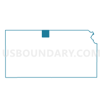
Outline

Summary
| Unique Area Identifier | 587423 |
| Name | Beaver Township Voting District |
| County | Smith County |
| State | Kansas |
| Area (square miles) | 36.01 |
| Land Area (square miles) | 35.86 |
| Water Area (square miles) | 0.15 |
| % of Land Area | 99.59 |
| % of Water Area | 0.41 |
| Latitude of the Internal Point | 39.96598110 |
| Longtitude of the Internal Point | -98.79310960 |
Maps


Graphs
Select a template below for downloading or customizing gragh for Beaver Township Voting District, Smith County, Kansas


Neighbors
Neighoring Voting District (by Name) Neighboring Voting District on the Map
- Cora Township Voting District, Smith County, KS
- East Franklin Precinct, Franklin County, NE
- Martin Township Voting District, Smith County, KS
- Pawnee Township Voting District, Smith County, KS
- Pleasant Township Voting District, Smith County, KS
- Washington Township Voting District, Smith County, KS
Top 10 Neighboring County Subdivision (by Population) Neighboring County Subdivision on the Map
- Washington township, Franklin County, NE (123)
- Washington township, Smith County, KS (57)
- Beaver township, Smith County, KS (48)
- Pleasant township, Smith County, KS (37)
- Cora township, Smith County, KS (26)
- Pawnee township, Smith County, KS (24)
- Martin township, Smith County, KS (18)